The critical task of damage claim processing is typically labor-intensive and requires a significant amount of time.
This demo, released at GTC Digital 2020, shows the workflow USAA used to perform damage assessment after the Woolsey fire, a wildfire that damaged thousands of homes and burned over 97,000 acres in parts of Los Angeles and Ventura Counties in California in 2019.
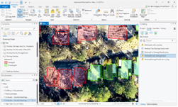
The demo shows the workflow from training the deep learning model to inferencing, which ultimately automated the detection of damaged homes. The deep learning tools within Esri ArcGIS, a geographic information system for working with maps and geographic information maintained by Esri, sped up the process to provide aid to those affected by this disaster.
For this demo, the developers used a client-server architecture, which gives a clean separation of the roles of a Geographic Information System Analyst (GIS), and a Data Scientist. The GIS Analyst used an NVIDIA Quadro Virtual Data Center Workstation to create, edit and explore spatial data. The data scientist used the NVIDIA Virtual Compute Server software to train/build a model which was used by the GIS Analyst to execute object detection Inferencing.
View the Demo
Click on the link below the video to watch the new demo (note: you must register for a free GTC Digital account to view the full video).