Monitoring infrastructure quality in developing regions is a major goal for international aid organizations, unfortunately gathering up to date and reliable data is expensive and a time-consuming process. To alleviate the burden on aid organizations, researchers from Stanford University developed a deep learning-based method that can assess infrastructure quality from satellite imagery.
“Basic infrastructure availability in developing regions is a crucial indicator of quality of life. Reliable infrastructure measurements create opportunities for effective planning and distribution of resources, as well as guiding policy decisions on the basis of improving the returns of infrastructure investments,” the researchers stated in their paper. “Currently, the most reliable infrastructure data in the developing world comes from field surveys, and these surveys are expensive and logistically challenging.”
Using NVIDIA Tesla GPUs on the Google Cloud, with the cuDNN-accelerated TensorFlow deep learning framework, the team trained their neural network on 10m and 30m resolution satellite imagery from the Sentinel 1 and Landsat 8 satellites. The satellites provided the team with thousands of images encompassing 36 countries in Africa.
“Our work provides the ability to assess infrastructure in an accurate and automated manner, to supplement the spatial extent of field survey data, and to generate predictions in unseen regions. To the best of our knowledge, we are the first to use CNNs with Sentinel 1 imagery for social development research,” the team said.
“Intuitively, and as our models show, these variables are feature-defined structures and infrastructure systems that are uniquely distinguishable from satellite imagery,” the researchers said.
In future projects, the researchers say they will focus on getting satellite data with much higher resolution.
“The quality of a deep model heavily relies on adequate data available, and a large focus should be towards making better use of existing image and survey data, through strong cataloging and collating efforts. However, our results demonstrate the proof of concept that satellite imagery can be used to predict infrastructure quality,” the researchers said.
Read more >
AI Assesses Infrastructure Quality in Africa
Jul 02, 2018
Discuss (0)
AI-Generated Summary
- Researchers from Stanford University developed a deep learning-based method to assess infrastructure quality in developing regions using satellite imagery, aiming to aid international aid organizations.
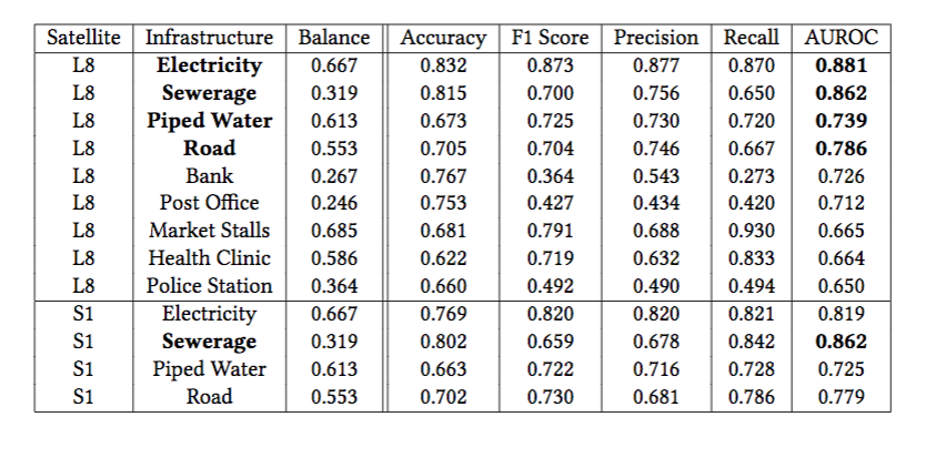
- The team trained a neural network on satellite imagery from Sentinel 1 and Landsat 8 satellites, achieving high UROC scores for predicting infrastructure quality, particularly for electricity and sewerage.
- The researchers plan to improve their model by utilizing higher resolution satellite data in future projects, emphasizing the importance of adequate data for deep learning models.
AI-generated content may summarize information incompletely. Verify important information. Learn more