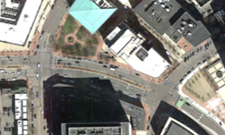
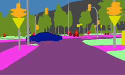
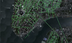
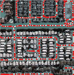
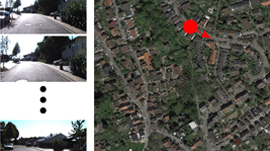
In the third SpaceNet challenge, competitors were tasked with finding automated methods for extracting map-ready road networks from high-resolution satellite imagery. This move towards automated extraction of road networks will help bring innovation to computer vision methodologies applied to high-resolution satellite imagery and ultimately help create better maps where they are needed most such as humanitarian efforts, disaster response, and operations.
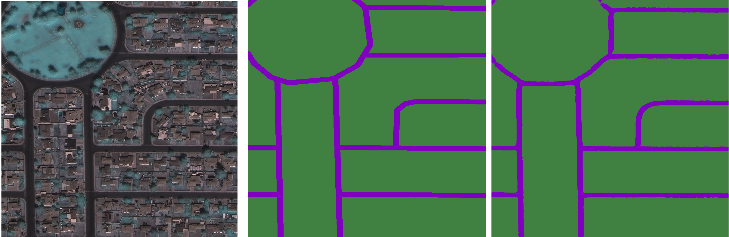
A new NVIDIA Developer Blog post describes how to directly leverage the full 8-band imagery and manipulate ground truth labels to obtain excellent road networks with relative ease and excellent performance. The first part of the blog describes how to exploit the material properties of the road surface itself by using the spectral aspect of the data to create a deep learning solution tailored for a specific spectral signature. Finally, it takes a look at how to use creative liberties to think about how we might apply these types of deep learning solutions in a broader operational sense using conditional random fields, percolation theory, and reinforcement learning. Think of this like Bohemian Rhapsody for deep learning (minus the Grammy Hall of Fame).
Read more >
Using Deep Learning to Help Solve the SpaceNet Road Detection Challenge

Feb 20, 2018
Discuss (0)
AI-Generated Summary
- The third SpaceNet challenge aimed to develop automated methods for extracting road networks from high-resolution satellite imagery to improve map creation for humanitarian efforts and disaster response.
- A new NVIDIA developer blog post explains how to use 8-band imagery and manipulate ground truth labels to achieve excellent road network extraction performance using deep learning.
- The blog post also explores broader applications of deep learning solutions using techniques like conditional random fields, percolation theory, and reinforcement learning.
AI-generated content may summarize information incompletely. Verify important information. Learn more