To reveal deeper insights into important activities taking place around the world, DigitalGlobe’s advanced satellite constellation collects nearly 4 million km2 of high-resolution earth imagery each day.
The company announced they will now rely on NVIDIA GPUs and deep learning to automatically identify objects such as airplanes, vehicles, and gray elephants, as well as to detect patterns from their massive volumes of big data satellite imagery.
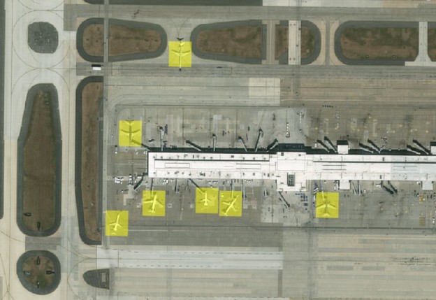
This technology has a wide variety of uses within defense and intelligence, civil agencies, mapping and analysis, environmental monitoring, oil and gas exploration, infrastructure management, Internet portals, and navigation technology.
Read more >>
Detecting Objects from Space with Artificial Intelligence
Feb 03, 2016
Discuss (0)
AI-Generated Summary
- DigitalGlobes satellite constellation collects nearly 4 million km2 of high-resolution earth imagery daily to provide insights into important global activities.
- The company is now using NVIDIA GPUs and deep learning to automatically identify objects such as airplanes, vehicles, and gray elephants from their satellite imagery.
- This technology has various applications across defense, civil agencies, mapping, environmental monitoring, and infrastructure management.
AI-generated content may summarize information incompletely. Verify important information. Learn more