Case Study
How Space42 Creates Urban Height Maps from SAR Imagery with NVIDIA Earth-2

About Space42: Space42, part of the technology group G42 based in the United Arab Emirates, is an AI-powered SpaceTech company that integrates satellite communications, geospatial analytics, and AI. Through its Space Services and Smart Solutions businesses, it delivers connectivity and geospatial intelligence to customers worldwide.
Challenge
What Space42 needed to do
Space42 set out to generate a digital surface model (DSM) from a single synthetic aperture radar (SAR) image acquired by their satellites. Unlike optical imagery, SAR can operate through clouds, dust, rain, and low-light conditions, making it valuable for rapid urban assessment. However, its side-looking geometry creates layover and shadows, making building height difficult to infer.
Space42 needed to recover useful height estimates despite this ambiguity while identifying areas where analysts should treat the predictions with caution. Existing regression approaches produced overly smooth results and failed to preserve building boundaries in dense areas.
Constraints
Timeliness: Emergency mapping and rapid urban assessment required generating a DSM from a single SAR view when multi-view or multi-temporal data were unavailable.
-
Uncertainty quantification: Dense urban areas with tall buildings, layover, façades, and heavy shadowing required the model to communicate where its estimates couldn’t be trusted.
Learning from limited data: The model had to learn from seven geographically separated SAR acquisitions paired with a LiDAR-derived reference DSM while preventing spatial leakage between training and evaluation data.
System architecture
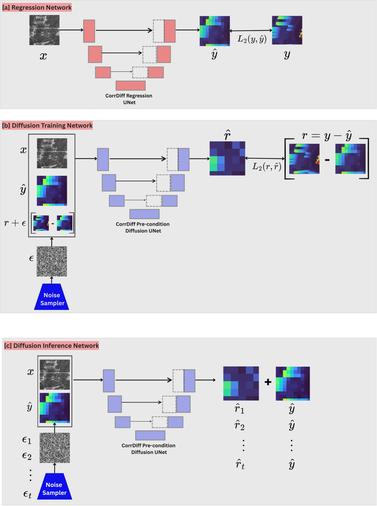
Space42 developed SARDiff4Height, a two-stage system that estimates surface height and uncertainty from a single SAR image. A regression U-Net first predicts the mean DSM. A diffusion model then learns the residual between that prediction and the reference DSM and generates multiple plausible refinements. The pixel-wise spread across those outputs forms an uncertainty map that helps identify less reliable predictions.
Architecture overview:
Regression stage
A geometry-aware U-Net predicts the mean DSM from the SAR input, capturing the principal terrain and building-height structure.
Diffusion stage
A diffusion model learns the residual between the mean prediction and the reference DSM, enabling it to recover finer local structure.
Uncertainty output
During inference, the model generates multiple residual samples. Their pixel-wise spread produces an uncertainty map that highlights areas where predictions vary.
Integration details
Key design decisions
Space42 made two key changes to adapt the regression model to SAR geometry and improve its performance in dense urban scenes:
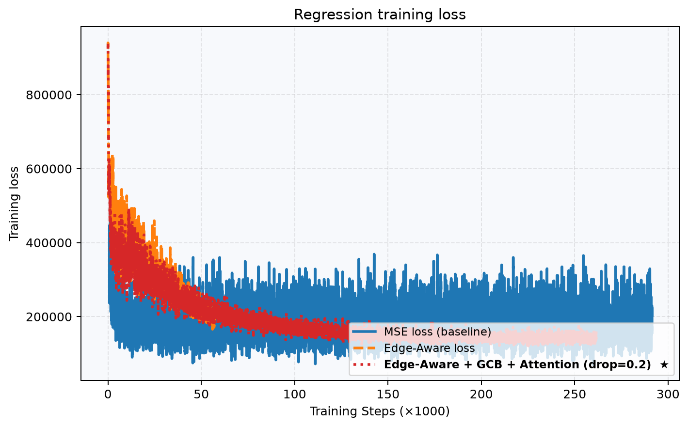
Edge-aware regression loss: A plain U-Net with standard MSE smooths building edges and misses sharp urban transitions. The final objective combines height accuracy with gradient consistency: ||ŷ − y||²₂ + λ||∇ŷ − ∇y||₁. Edge-aware supervision preserves boundaries but must be paired with regularization because, by itself, it can overfit training edges.
-
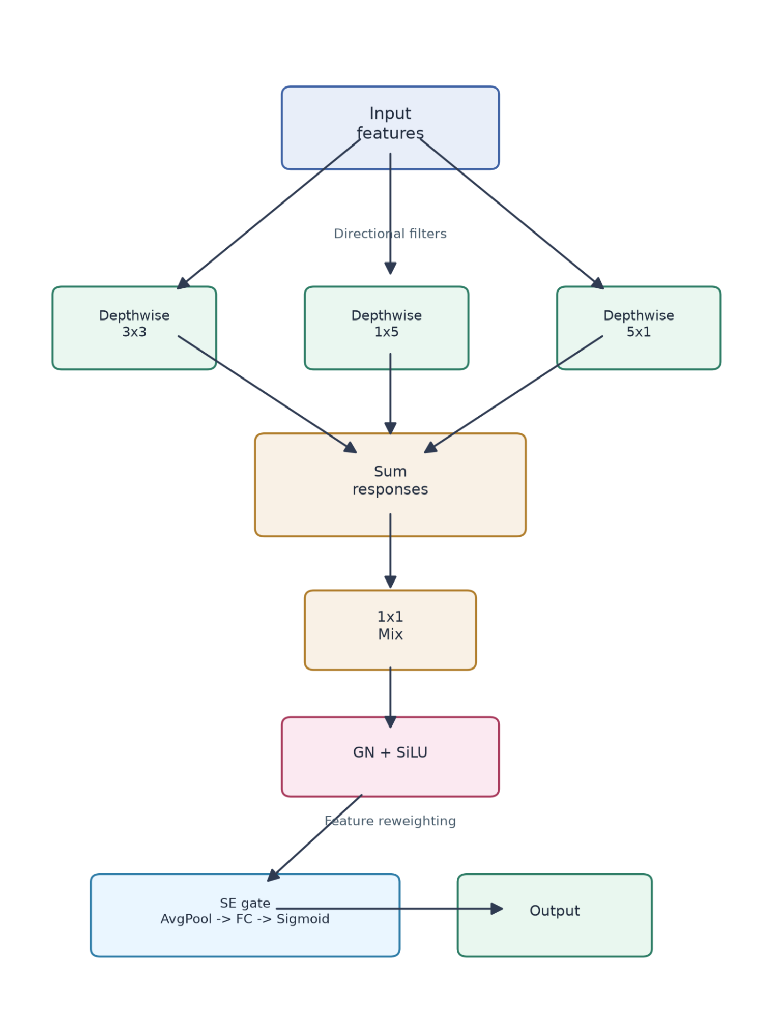
Geometry Context Block: At the bottleneck of the regression U-Net, depthwise branches capture local, range-oriented, and azimuth-oriented structure. A shared mixer combines their responses, and a squeeze-excitation gate reweights the most informative channels. Bottleneck self-attention, spatial dropout, and DropPath further stabilize training and improve generalization.
How PhysicsNeMo was integrated
The open-source code for training NVIDIA Earth-2 models is found in the NVIDIA PhysicsNeMo package. Space42 used the PhysicsNeMo regional diffusion models recipe as the foundation for CorrDiff training and inference, adapting it for SAR data and geometry-aware modeling.
Data preparation and configuration: Space42 projected the LiDAR-derived DSM into radar geometry and filtered invalid or weakly supported pixels before training. The training recipe uses Hydra YAML files to control the dataset, model, loss, and training configuration.
-
Staged training: The regression model first learned the broad height structure using the edge-aware loss and Geometry Context Block. The diffusion model was then trained on the residual around that mean prediction.
What didn’t work initially
A plain U-Net with mean squared error produced unstable training and overly smooth predictions. Edge-aware loss improved building boundaries, but overfitting remained a problem. Adding geometry-aware context, attention, spatial dropout, and DropPath stabilized the mean predictor, giving diffusion a stronger foundation for residual refinement.
Results
Measured outcomes:
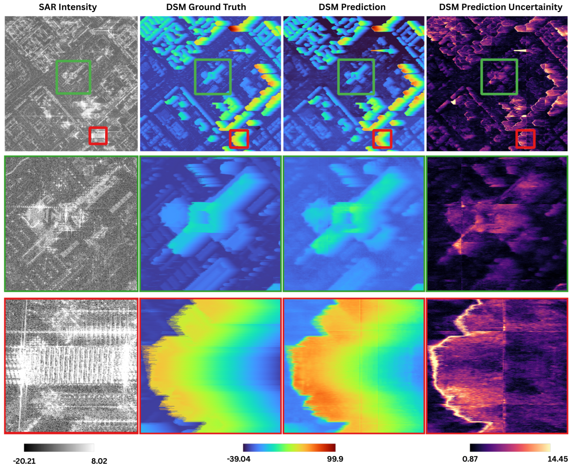
On held-out test data, the final model achieved an RMSE of 3.04 m, MAE of 1.68 m, R² of 0.8467, and relative error of 2.85%. Errors and predictive variance were higher around building edges, dense high-rise areas, and regions affected by SAR layover and shadowing.
Comparison of Digital Surface Models
Before and after comparisons:
Diffusion improved results only after the regression model produced a meaningful mean prediction:
Weak baseline: The initial regression model had a test R² near zero, and diffusion improved R² by only about 0.01.
Enhanced model: Across the 126-patch evaluation subset, regression achieved an R² of 0.923, and diffusion improved it to 0.970. For the displayed patch, R² increased from 0.692 to 0.804.
Abu Dhabi stitched-scene uncertainty analysis
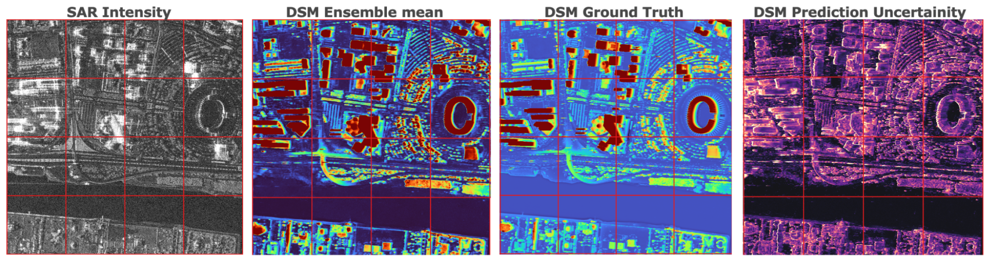
Out-of-distribution behavior
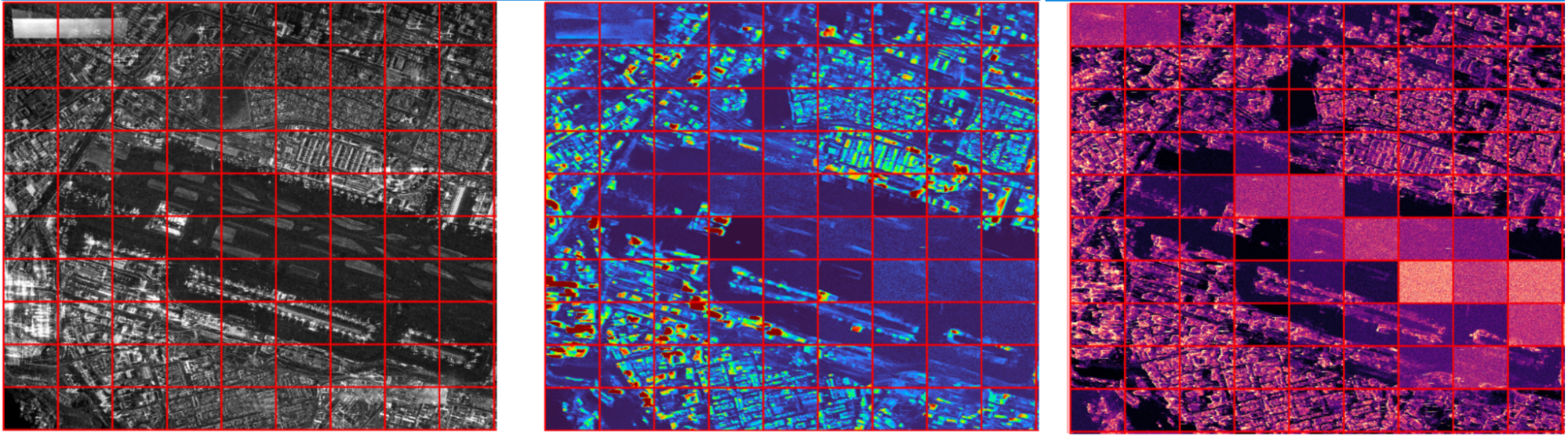
Lessons Learned
Strategies for success
Build the mean predictor first: Establish a stable mean DSM predictor before training the residual diffusion model. Geometry-aware context and regularization gave diffusion a meaningful prediction to refine.
Avoid geometry misalignment: Misalignment teaches the model an incorrect relationship between SAR features and surface height. Instead, train against a reference DSM that has been projected into radar geometry.
Test beyond the training geography: Use geographically distinct scenes to evaluate uncertainty under difficult or unfamiliar conditions. This helps reveal whether the uncertainty signal remains useful beyond the training locations.
Acknowledgements
Many thanks to Younes Abid, Pavan Muguda Sanjeevamurthy, Naseema B Shyju, Emmanuel Fall, Vincent Markiet, Lucas Gaspare Traina, Artur Jach, Yuliya Tarabalka, Prashanth Reddy Marpu, and Javier Marin at Space42, as well as Jussi Leinonen and Farah Hariri at NVIDIA, for their contributions to the research and development at Space42 and the writing of this case study.